For funsies I just googled "Shoprite near me". The traffic meter is almost pegged at "as busy as it gets". We will need an update from the French Toast Indicator
Colleges
- American Athletic
- Atlantic Coast
- Big 12
- Big East
- Big Ten
- Colonial
- Conference USA
- Independents (FBS)
- Junior College
- Mountain West
- Northeast
- Pac-12
- Patriot League
- Pioneer League
- Southeastern
- Sun Belt
- Army
- Charlotte
- East Carolina
- Florida Atlantic
- Memphis
- Navy
- North Texas
- Rice
- South Florida
- Temple
- Tulane
- Tulsa
- UAB
- UTSA
- Boston College
- California
- Clemson
- Duke
- Florida State
- Georgia Tech
- Louisville
- Miami (FL)
- North Carolina
- North Carolina State
- Pittsburgh
- Southern Methodist
- Stanford
- Syracuse
- Virginia
- Virginia Tech
- Wake Forest
- Arizona
- Arizona State
- Baylor
- Brigham Young
- Cincinnati
- Colorado
- Houston
- Iowa State
- Kansas
- Kansas State
- Oklahoma State
- TCU
- Texas Tech
- UCF
- Utah
- West Virginia
- Illinois
- Indiana
- Iowa
- Maryland
- Michigan
- Michigan State
- Minnesota
- Nebraska
- Northwestern
- Ohio State
- Oregon
- Penn State
- Purdue
- Rutgers
- UCLA
- USC
- Washington
- Wisconsin
High Schools
- Illinois HS Sports
- Indiana HS Sports
- Iowa HS Sports
- Kansas HS Sports
- Michigan HS Sports
- Minnesota HS Sports
- Missouri HS Sports
- Nebraska HS Sports
- Oklahoma HS Sports
- Texas HS Hoops
- Texas HS Sports
- Wisconsin HS Sports
- Cincinnati HS Sports
- Delaware
- Maryland HS Sports
- New Jersey HS Hoops
- New Jersey HS Sports
- NYC HS Hoops
- Ohio HS Sports
- Pennsylvania HS Sports
- Virginia HS Sports
- West Virginia HS Sports
ADVERTISEMENT
OT: Potential Significant to Major Winter Storm Saturday, 1/29/22 (but high uncertainty)
- Thread starter RU848789
- Start date
Actually, in hindsight, the 12Z models, at least the 4 main globals are not all over the place and they're much closer to each other than they've ever been during this whole event progression. Obviously, this is what should happen close to an event, but after all the mayhem (and we'll likely still see some, especially from the meso/CAM/short-range models and of course from the radar), it's fascinating to see. The NWS forecast for the Philly/NYC AFDs, below, is looking pretty good right now, depending of course, on how they account for ratios (still on a quest to find that out), but I included all 4 globals with both Kuchera (roughly 15:1 for most) and the usual 10:1 ratio maps (except the UK, which I only have as a 10:1 map).
Here are the 4 globals at 10:1 ratios...


Here are 3 of the globals with Kuchera ratios (roughly 15:1 or 1.5X that of the 10:1 maps); UK doesn't have a Kuchera map and we think the NWS uses an in-house ratio algorithm for ratios that is likely in the 12-14:1 ratio level for this event...


Finally found out how to find what the NWS is using for their snow ratios when they make their snowfall maps and for the locations around the 95 corridor and the coast, at least, that ratio is around 14:1, based on the data NWS actually has buried in their point forecast matrices, where they show the liquid amount that falls along with the snow accumulation.
Given that Kuchera uses about 15:1 for 95/coast from what I've seen, from here on out, I'm going to post Kuchera maps for this event, as it's definitely closer to what the NWS is expecting for snow to liquid ratios - of course, it doesn't mean they're right, but I'd rather go with their analysis/experience than anyone else's. In the example below for NYC, they're calling for 0.64" of liquid and 9" of snow for a ratio of 13.8:1. Cool stuff - have always wondered that.
POINT FORECAST MATRICES
NATIONAL WEATHER SERVICE NEW YORK NY
322 PM EST FRI JAN 28 2022
NYZ072-290900-
CENTRAL PARK-NEW YORK NY
40.78N 73.97W ELEV. 16 FT
322 PM EST FRI JAN 28 2022
DATE 01/28/22 SAT 01/29/22 SUN 01/30/22 MON
EST 3HRLY 16 19 22 01 04 07 10 13 16 19 22 01 04 07 10 13 16 19 22 01 04 07
UTC 3HRLY 21 00 03 06 09 12 15 18 21 00 03 06 09 12 15 18 21 00 03 06 09 12
MIN/MAX 19 24 12 26 18
TEMP 33 33 31 28 24 20 17 17 21 21 14 12 14 13 18 23 24 23 22 22 20 19
DEWPT 28 26 23 20 17 14 12 11 7 3 -2 -2 -1 2 5 8 8 8 9 10 10 11
RH 82 75 72 71 74 77 80 77 54 45 48 52 50 61 56 52 50 52 57 59 64 70
WIND DIR NE N N N N N N N NW NW NW NW NW NW NW W W W W W NW N
WIND SPD 2 8 10 14 17 21 27 24 25 21 21 18 18 16 14 12 11 10 8 5 3 2
WIND GUST 28 37 39 36 34
CLOUDS OV OV OV OV OV OV OV OV OV OV B1 FW FW FW FW FW FW SC SC B1 B1 B1
POP 12HR 100 90 30 0 0
QPF 12HR 0.27 0.37 0.01 0 0
SNOW 12HR 4 5 T
SNOW C C D D D D D C C C
WIND CHILL 26 22 16 10 4 -2 -1 4 5 -4 -6 -3 -3 4 11 13 12 13 15
MIN CHILL 26 16 4 -3 0 -6 -5 -1 12 13 13
WINTER STORM W W W W W W W W
https://kamala.cod.edu/nj/latest.fous51.KOKX.html
The weenies on americanwx are either in the Anger phase or the Bargaining phase of grief. That recent NAM run must have been brutal. And yet, Mt Holly upped snow totals in the Hamilton area again, hedging to the high side of estimates. The storm kicks off in a couple hours...absolutely fascinating.
They're fashion models. They always look (and are) young, and like they did a few lines, put a needle in their arms, and haven't eaten in 3 years. Walking clothes hangers, basically.What, are they 16 years old? They all look like they did a few lines, put a needle in their arms, haven't eaten in 3 years, YIKES!
Always struck me as odd that fashion models look utterly unlike the vast majority of folks who might actually buy what they're wearing at a fashion show. But I live in shorts and sweatpants and t-shirts or sweat-shirts. So what do I know?
Anyway, I was just grabbing the first line up of models image I could find.
You're saying they have moleiosis?Pass also. The first one looks like a man and the rest have moles on their cheeks.
Ugh. That might be the worst bad dad joke I've ever made. And I've made some bad ones.
The weenies on americanwx are either in the Anger phase or the Bargaining phase of grief. That recent NAM run must have been brutal. And yet, Mt Holly upped snow totals in the Hamilton area again, hedging to the high side of estimates. The storm kicks off in a couple hours...absolutely fascinating.
to cover their bases...we shall see in the post mortem
I'm going to get a nice buzz and see the conditions at 10/11. Will probably clear it all if it's a couple of inches so less to do in the morning around 6/7.
It's going to depend on timing.
Anywhere past 11pm or so, I'm already deep enough into Friday Night that operating heavy machinery is contraindicated.
Maybe 4 for Somerville.Mt holly putting out a bullish range..i don't see 11 in somerville
Those were the first thing that came up in a Google search for "fashion model". My collection looks more like this:first of all you better better model pics from your collection

It's going to depend on timing.
Anywhere past 11pm or so, I'm already deep enough into Friday Night that operating heavy machinery is contraindicated.
I'm just worried about bugging neighbors with having garage light on (it faces their house) and sound of me shoveling at 10/11 or so. No snow blower.
Maybe I'm just being too accommodating.
That reminds me, I need to go to the store because I forgot the bread and the milk!
Looks like someone just went shoe shopping
Speaking of busts, that busted my prior theory about your preferences.
Hey I ran into them at the Hillsborough Deli earlier this week!
The blond is a friend of my wife.Hey I ran into them at the Hillsborough Deli earlier this week!
The updated NWS winter storm and blizzard warnings for Philly/NYC offices and the advisory for NWNJ/SEPA at the bottom...so maps should be out shortly
URGENT - WINTER WEATHER MESSAGE
National Weather Service Mount Holly NJ
330 PM EST Fri Jan 28 2022
New Castle-Kent-Kent MD-Queen Annes-Talbot-Caroline-
Including the cities of Wilmington, Dover, Chestertown,
Centreville, Easton, and Denton
330 PM EST Fri Jan 28 2022
...WINTER STORM WARNING REMAINS IN EFFECT FROM 7 PM THIS EVENING
TO 3 PM EST SATURDAY...
* WHAT...Heavy snow expected. Total snow accumulations of 5 to 10
inches. Winds gusting as high as 40 mph.
URGENT - WINTER WEATHER MESSAGE
National Weather Service Mount Holly NJ
330 PM EST Fri Jan 28 2022
Morris-Hunterdon-Somerset-Middlesex-Mercer-Salem-Gloucester-
Camden-Northwestern Burlington-Cumberland-Delaware-Philadelphia-
Eastern Montgomery-Lower Bucks-
Including the cities of Morristown, Flemington, Somerville,
New Brunswick, Trenton, Pennsville, Glassboro, Camden,
Cherry Hill, Moorestown, Mount Holly, Millville, Media,
Philadelphia, Norristown, Lansdale, Morrisville, and Doylestown
330 PM EST Fri Jan 28 2022
...WINTER STORM WARNING REMAINS IN EFFECT FROM 7 PM THIS EVENING
TO 7 PM EST SATURDAY...
* WHAT...Heavy snow expected. Total snow accumulations of 5 to
11 inches. Winds gusting as high as 40 mph.
URGENT - WINTER WEATHER MESSAGE
National Weather Service New York NY
331 PM EST Fri Jan 28 2022
Western Passaic-Eastern Passaic-Western Bergen-Eastern Bergen-
Western Essex-Eastern Essex-Western Union-Eastern Union-Putnam-
Rockland-Northern Westchester-
331 PM EST Fri Jan 28 2022
...WINTER STORM WARNING REMAINS IN EFFECT FROM 7 PM THIS EVENING
TO 7 PM EST SATURDAY...
* WHAT...Heavy snow expected. Total snow accumulations of 4 to 7
inches. Winds gusting as high as 40 mph.
URGENT - WINTER WEATHER MESSAGE
National Weather Service New York NY
331 PM EST Fri Jan 28 2022
Northern Fairfield-Southern Fairfield-Hudson-Southern Westchester-
New York (Manhattan)-Bronx-Richmond (Staten Island)-
Kings (Brooklyn)-Northern Queens-Southern Queens-
331 PM EST Fri Jan 28 2022
...WINTER STORM WARNING REMAINS IN EFFECT FROM 7 PM THIS EVENING
TO 7 PM EST SATURDAY...
* WHAT...Heavy snow expected. Total snow accumulations of 7 to 10
inches. Winds gusting as high as 45 mph. Near blizzard
conditions are possible for a period on Saturday.
URGENT - WINTER WEATHER MESSAGE
National Weather Service New York NY
331 PM EST Fri Jan 28 2022
Northern New Haven-Northern Middlesex-Southern New Haven-
Southern Middlesex-Northern Nassau-Southern Nassau-
331 PM EST Fri Jan 28 2022
...WINTER STORM WARNING REMAINS IN EFFECT FROM 7 PM THIS EVENING
TO 7 PM EST SATURDAY...
* WHAT...Heavy snow expected. Total snow accumulations of 9 to 12
inches. Winds gusting as high as 45 mph. Near blizzard
conditions are possible for a period on Saturday.
URGENT - WINTER WEATHER MESSAGE
National Weather Service Mount Holly NJ
330 PM EST Fri Jan 28 2022
Inland Sussex-Delaware Beaches-Western Monmouth-Eastern Monmouth-
Ocean-Atlantic-Cape May-Atlantic Coastal Cape May-
Coastal Atlantic-Coastal Ocean-Southeastern Burlington-
Including the cities of Georgetown, Rehoboth Beach, Freehold,
Sandy Hook, Jackson, Hammonton, Cape May Court House, Ocean City,
Atlantic City, Long Beach Island, and Wharton State Forest
330 PM EST Fri Jan 28 2022
...BLIZZARD WARNING REMAINS IN EFFECT FROM 7 PM THIS EVENING TO
7 PM EST SATURDAY...
* WHAT...Blizzard conditions expected. Total snow accumulations of
10 to 18 inches. Winds gusting as high as 50 mph.
URGENT - WINTER WEATHER MESSAGE
National Weather Service New York NY
331 PM EST Fri Jan 28 2022
Northwest Suffolk-Southwest Suffolk-
331 PM EST Fri Jan 28 2022
...BLIZZARD WARNING REMAINS IN EFFECT FROM 7 PM THIS EVENING TO
7 PM EST SATURDAY...
* WHAT...Blizzard conditions expected. Total snow accumulations
of 12 to 16 inches. Winds gusting as high as 55 mph.
URGENT - WINTER WEATHER MESSAGE
National Weather Service New York NY
331 PM EST Fri Jan 28 2022
Northern New London-Southern New London-Northeast Suffolk-
Southeast Suffolk-
331 PM EST Fri Jan 28 2022
...BLIZZARD WARNING REMAINS IN EFFECT FROM 7 PM THIS EVENING TO
7 PM EST SATURDAY...
* WHAT...Blizzard conditions expected. Total snow accumulations
of 13 to 17 inches. Winds gusting as high as 60 mph.
And the NWS advisory for NWNJ/SEPA
URGENT - WINTER WEATHER MESSAGE
National Weather Service Mount Holly NJ
330 PM EST Fri Jan 28 2022
Sussex-Warren-Western Chester-Eastern Chester-Western Montgomery-
Upper Bucks-
Including the cities of Newton, Washington, Honey Brook, Oxford,
West Chester, Kennett Square, Collegeville, Pottstown, Chalfont,
and Perkasie
330 PM EST Fri Jan 28 2022
...WINTER WEATHER ADVISORY REMAINS IN EFFECT FROM 7 PM THIS
EVENING TO 3 PM EST SATURDAY...
* WHAT...Snow expected. Total snow accumulations of 3 to 5
inches. Winds gusting as high as 35 mph.
Storm's going to start soon, folks - probably by 9-10 pm for most, lightly, and the heaviest snow will fall between about 1 am and 11 am Saturday, so be safe, but enjoy...
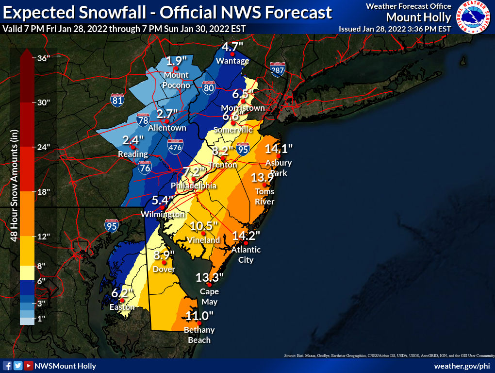
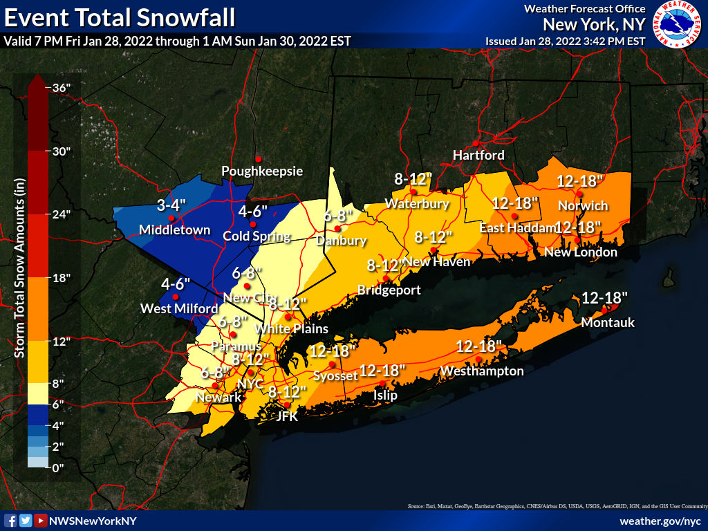
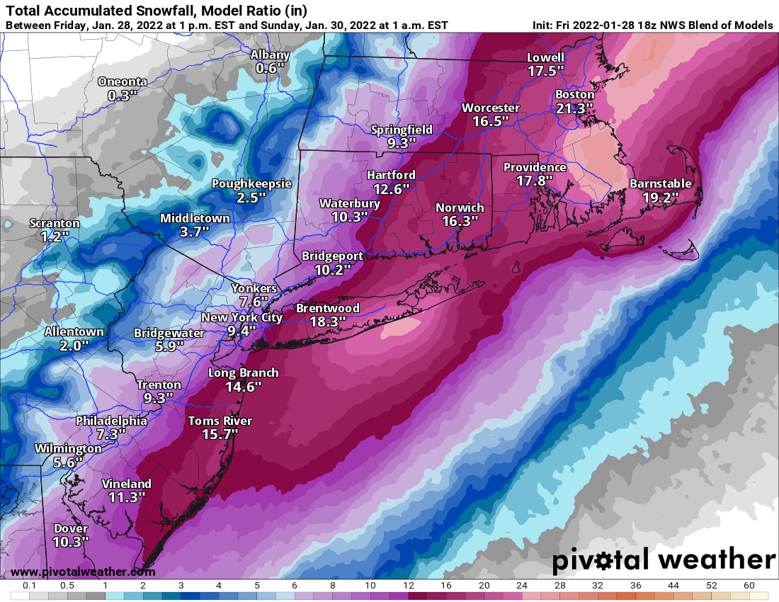
Updated NWS snowfall maps, below, which have been increased a small amount (an inch or so in most places) vs. 4 am this morning. Also, as per below, they're generally using a snow:liquid ratio of 14:1, which is close to the Kuchera ratio of 15:1 for snowfall maps for this event, at least for 95/coast. I also included the NBM, national blend of models snowfall map that the NWS often uses to guide their forecasts. Think I've had enough of models and maps - time to watch the radar, observations, meso trends and looking out my window and enjoying it all - even shoveling, lol.
One last time: this setup is exquisitely delicate and volatile, such that small changes, even now, could have substantial impacts on the snowfall. As such, the bust potential on both the low and high side is higher than normal.
https://www.weather.gov/phi/
https://www.33andrain.com/topic/208...cussion/page/314/?tab=comments#comment-317275
Last edited:
Updated NWS snowfall maps, below, which have been increased a small amount (an inch or so in most places) vs. 4 am this morning. Also, as per my recent post, they're generally using a snow:liquid ratio of 14:1, which is close to the Kuchera ratio of 15:1 for snowfall maps for this event, at least for 95/coast. I also included the NBM, national blend of models snowfall map that the NWS often uses to guide their forecasts. Think I've had enough of models and maps - time to watch the radar, observations, meso trends and looking out my window and enjoying it all - even shoveling, lol.
https://www.weather.gov/phi/
https://www.33andrain.com/topic/208...cussion/page/314/?tab=comments#comment-317275


see this is better than their text product which lumps a whole bunch of disparate cities with some huge range of totals
This is going to bust. Just a hunch. No one in nj gets a foot.
And the pointy elbows! Yuck!Pass also. The first one looks like a man and the rest have moles on their cheeks.
Agreed, but that's the limitation of having whole counties in those products - almost every county would benefit from being split for events like this, like several are already (Bergen, Passaic, Union, Essex, Burlington, and coastal Monmouth/Ocean). Maps are way better and I still think the NWS map is a little high, but we'll see soon...see this is better than their text product which lumps a whole bunch of disparate cities with some huge range of totals
Because the gradient from a lot to a little snow is closer to the NJ coast than it is to Suffolk, LI, so could easily see 18" in Belmar, but 9" in Freehold, both in the same county.What time do we expect it to get going? I also read the latest warnings. They’re much firmer on the island and in Connecticut than at the shore. .. 10-18 here with ranges of only 4 inches out there. Why is that
Based on BACs pictures I see both a bust and also 36 inches.This is going to bust. Just a hunch. No one in nj gets a foot.
I know it's weenie land, but I can't see why they are so pissed off. Most of the area is getting significant snow out of this storm. I know, I know, Numbers explained this to me already. It's all about expectations.The weenies on americanwx are either in the Anger phase or the Bargaining phase of grief. That recent NAM run must have been brutal. And yet, Mt Holly upped snow totals in the Hamilton area again, hedging to the high side of estimates. The storm kicks off in a couple hours...absolutely fascinating.
Burlington County starts at the Delaware River and ends at the Great Bay, North of AC. It will easily get the greatest differential between high and low totals for any countyAgreed, but that's the limitation of having whole counties in those products - almost every county would benefit from being split for events like this, like several are already (Bergen, Passaic, Union, Essex, Burlington, and coastal Monmouth/Ocean). Maps are way better and I still think the NWS map is a little high, but we'll see soon...
Disagree with this. Plenty of spots at the shore will get 12"+ - the bust area is along and NW of 95, where the gradient from SE to NW is so, so sharp. Could see something like 6" in Dunellen, 11" in Keyport and 15" in Belmar, but if the storm moves east 25 miles that could end up as 3" in Dunellen, 8" in Keyport and 14" in Belmar, as Belmar has so much more margin for error in a bust scenario, as it's far from the gradient.This is going to bust. Just a hunch. No one in nj gets a foot.
That's why it's split into SE and NW parts for weathe forecasts - should be done for others...Burlington County starts at the Delaware River and ends at the Great Bay, North of AC. It will easily get the greatest differential between high and low totals for any county
Sounds like folks are trying to one up each other on wishcasting!Mt holly putting out a bullish range..i don't see 11 in somerville
Similar threads
- Replies
- 748
- Views
- 38K
- Replies
- 44
- Views
- 3K
- Replies
- 152
- Views
- 8K
ADVERTISEMENT


