Umm... No, "they" don't. If you don't have any sort of property lien (mortgage, etc.) then you don't have to have flood insurance.


Colleges
- American Athletic
- Atlantic Coast
- Big 12
- Big East
- Big Ten
- Colonial
- Conference USA
- Independents (FBS)
- Junior College
- Mountain West
- Northeast
- Pac-12
- Patriot League
- Pioneer League
- Southeastern
- Sun Belt
- Army
- Charlotte
- East Carolina
- Florida Atlantic
- Memphis
- Navy
- North Texas
- Rice
- South Florida
- Temple
- Tulane
- Tulsa
- UAB
- UTSA
- Boston College
- California
- Clemson
- Duke
- Florida State
- Georgia Tech
- Louisville
- Miami (FL)
- North Carolina
- North Carolina State
- Pittsburgh
- Southern Methodist
- Stanford
- Syracuse
- Virginia
- Virginia Tech
- Wake Forest
- Arizona
- Arizona State
- Baylor
- Brigham Young
- Cincinnati
- Colorado
- Houston
- Iowa State
- Kansas
- Kansas State
- Oklahoma State
- TCU
- Texas Tech
- UCF
- Utah
- West Virginia
- Illinois
- Indiana
- Iowa
- Maryland
- Michigan
- Michigan State
- Minnesota
- Nebraska
- Northwestern
- Ohio State
- Oregon
- Penn State
- Purdue
- Rutgers
- UCLA
- USC
- Washington
- Wisconsin
High School
- Illinois HS Sports
- Indiana HS Sports
- Iowa HS Sports
- Kansas HS Sports
- Michigan HS Sports
- Minnesota HS Sports
- Missouri HS Sports
- Nebraska HS Sports
- Oklahoma HS Sports
- Texas HS Hoops
- Texas HS Sports
- Wisconsin HS Sports
- Cincinnati HS Sports
- Delaware
- Maryland HS Sports
- New Jersey HS Hoops
- New Jersey HS Sports
- NYC HS Hoops
- Ohio HS Sports
- Pennsylvania HS Sports
- Virginia HS Sports
- West Virginia HS Sports
ADVERTISEMENT
Install the app
How to install the app on iOS
Follow along with the video below to see how to install our site as a web app on your home screen.
Note: This feature may not be available in some browsers.
You are using an out of date browser. It may not display this or other websites correctly.
You should upgrade or use an alternative browser.
You should upgrade or use an alternative browser.
OT: Tropics more active...Florence to make NC/SC landfall on 9/14
- Thread starter RU848789
- Start date

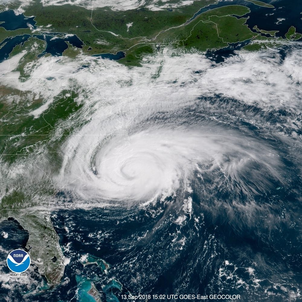
Florence's weakening stopped overnight, with Florence remaining a top end Cat-2 hurricane with 110 mph winds (Cat 3 is 111 mph or more). Florence has become quite a large storm, as hurricane force winds extend 80 mile out from the center, while the TS force winds extend 195 miles out from the center. Florence has been moving about 16-18 mph, but has slowed to 15 mph and is expected to slow to 5-7 mph during the day, as it approaches the NC coast, meaning Florence is likely to have hurricane force winds on the coast by about 8 pm tonight and to actually make landfall somewhere between 6 am and noon Friday, around Wilmington NC (more specifically on Wrightsville Beach, a few miles SE of Wilmington) with 100-110 mph winds, if the storm follows the center of the NHC track.
Obviously, there are still error bars around this track (+/-50 miles), so landfall could still be anywhere from Georgetown, SC (25 miles SW of Myrtle Beach SC and 50 miles NE of Charleston, SC) to Morehead City, NC, but the Wilmington area is a very good bet. Regardless of where the storm makes landfall, a slow moving hurricane moving W to WSW near/along the NC/SC coast is going to produce catastrophic rainfalls for the coast and up to 50-100 miles inland (20-30" near the coast and 10-20" up to 100 miles inland) and major to catastrophic storm surges along this part of the NC/SC coasts of 6-13 feet. There will also be some tornadoes, generally to the N of the center of the storm track.
The center of the NHC track shows Florence moving slowly SW along the NC/SC coast or just inland through Saturday morning, followed by a WSW movement into central SC, as a tropical storm then a tropical depression, through Saturday and then a W, then NW movement towards Greenville, SC through Sunday. The main thread during this time is obviously 10-20" rains near the track and 5-10" rains in the western half of NC and NW SC.
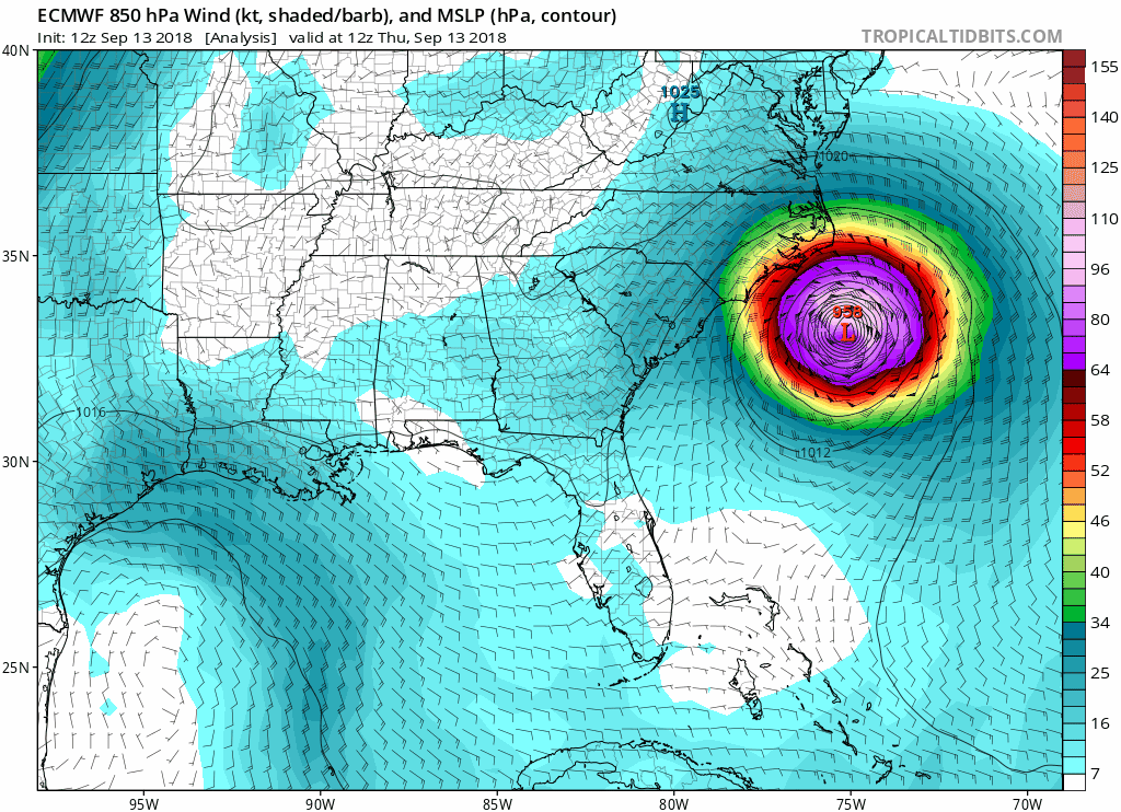
With regard to the 00Z models last night (7 pm EST data inputs), there continues to be pretty good consenus on the general track of Florence, as every major model brings Florence to a landfall within 25-50 miles of Wilmington, although the do diverge a bit after landfall.
The Euro shows Florence slowly moving SW along the SC coast as a Cat 1 hurricane through Saturday night, going inland around Charleston, then moving to Atlanta, then Greenville, SC as a tropical depression. This is a significant deviation from the NHC track, which starts going inland between Wilmington and the SC/NC border, which is generally what the UK, GFS and CMC all show. These models then bring the storm slowly across central SC from Friday night through Sunday, which is what the NHC track shows.

Here's the WPC rainfall forecast, which is scary..

And another scary graphic of the storm surge, along with the NHC surge amounts in table form...
STORM SURGE: The combination of a dangerous storm surge and the
tide will cause normally dry areas near the coast to be flooded by
rising waters moving inland from the shoreline. The water has the
potential to reach the following heights above ground if peak surge
occurs at the time of high tide...
Cape Fear NC to Cape Lookout NC, including the Neuse, Pamlico,
Pungo, and Bay Rivers...9-13 ft
North Myrtle Beach SC to Cape Fear NC...6-9 ft
Cape Lookout NC to Ocracoke Inlet NC...6-9 ft
South Santee River SC to North Myrtle Beach SC...4-6 ft
Ocracoke Inlet NC to Salvo NC...4-6 ft
Salvo NC to North Carolina/Virginia Border...2-4 ft
Edisto Beach SC to South Santee River SC...2-4 ft

No major or even minor changes to the forecast track or intensity with the 11 am NHC advisory. Winds are down to 105 mph, but the storm is definitely better organized than this morning and is expected to strengthen back to at least 110 mph and maybe 115 mph as it goes over the deep, warm Gulf stream in the next 6-12 hours. We'll see. Here's the updated track and intensities; the rainfall and storm surge graphics are about the same.
FORECAST POSITIONS AND MAX WINDS
INIT 13/1500Z 33.4N 75.5W 90 KT 105 MPH
12H 14/0000Z 33.9N 76.6W 95 KT 110 MPH
24H 14/1200Z 34.2N 77.8W 85 KT 100 MPH...NEAR THE COAST
36H 15/0000Z 34.1N 78.7W 65 KT 75 MPH...INLAND
48H 15/1200Z 34.0N 79.6W 45 KT 50 MPH...INLAND
72H 16/1200Z 34.3N 81.8W 25 KT 30 MPH...INLAND
96H 17/1200Z 36.9N 83.0W 25 KT 30 MPH...INLAND
120H 18/1200Z 40.3N 79.2W 20 KT 25 MPH...POST-TROP/EXTRATROP


US National Weather Service Philadelphia/Mount Holly
Here are the latest key messages on Hurricane Florence, which is tracking well to our south.

Here are the latest key messages on Hurricane Florence, which is tracking well to our south.
Here are the latest Key Messages from NHC regarding Hurricane Florence, issued by NHC at 11 a.m. EDT

HEAVY RAINBANDS WITH TROPICAL-STORM-FORCE WINDS SPREADING ACROSS THE OUTER BANKS AND COASTAL SOUTHEASTERN NORTH CAROLINA...
...LIFE-THREATENING STORM SURGE AND RAINFALL EXPECTED...
A Storm Surge Warning is in effect from the South Santee River, South Carolina, to Duck, North Carolina, and for Albemarle and Pamlico Sounds, including the Neuse and Pamlico Rivers. A Storm Surge Watch is in effect from Edisto Beach, South Carolina, to South Santee River, South Carolina, and from north of Duck North Carolina to the North Carolina/Virginia state line. A Hurricane Warning is in effect from the South Santee River, South Carolina, to Duck, North Carolina, and for Albemarle and Pamlico Sounds. A Hurricane Watch is in effect from Edisto Beach, South Carolina, to South Santee River, South Carolina. A Tropical Storm Warning is in effect from North of Duck, North Carolina, to Cape Charles Light, Virginia and from Chesapeake Bay south of New Point Comfort. Interests elsewhere in the southeastern and mid-Atlantic states should monitor the progress of Florence.
Hurricane Florence is centered at 11 a.m. EDT about 145 miles (230 km) east-southeast of Wilmington, N. Carolina. It's moving toward the northwest near 10 mph (17 km/h). On the forecast track, the center of Florence will approach the coasts of North and South Carolina later today, then move near or over the coast of southern North Carolina and northeastern South Carolina in the hurricane warning area tonight and Friday. A slow motion across portions of eastern South Carolina is forecast Friday night through Saturday night.
Data from the aircraft and Doppler weather radars indicate that maximum sustained winds have decreased to near 105 mph (165 km/h) with higher gusts. Little change in strength is expected before the center reaches the coast, with weakening expected after the center moves inland.
Florence is a large hurricane. Hurricane-force winds extend outward up to 80 miles (130 km) from the center and tropical-storm-force winds extend outward up to 195 miles (315 km). NOAA Buoy 41025, located near Diamond Shoals, North Carolina, recently reported a sustained wind of 54 mph (87 km/h). The next complete advisory will be issued by NHC at 5 p.m. with an intermediate advisory at 2 p.m. EDT
Umm... No, "they" don't. If you don't have any sort of property lien (mortgage, etc.) then you don't have to have flood insurance.
Exactly. I saw a graphic where only 20-25% of homeowners along the NC/SC coast have Flood insurance. I know it's crazy expensive if the lowest level floor isn't above the flood standard. Mine was $6,600 before the lift but still, what's the replacement cost?
Looking on Google Maps, I noticed several mobile home parks in towns on the Outer Banks, the only place I've seen them along the entire east coast. You've got to wonder what kind of building standards they have in North Carolina. Those things will be ripped up like cardboard boxes by 110 mph winds.
Was any explanation given for why the storm is weakening? Cooler water temps?Florence is weakening and is no longer expected to strengthen further prior to landfall. It will still be a strong storm but at this time no higher than Cat 3 is expected.
Was any explanation given for why the storm is weakening? Cooler water temps?
Wouldn't shock me if someone takes credit for it.
Was any explanation given for why the storm is weakening? Cooler water temps?
There was an eyewall replacement cycle that began yesterday and never completed. There are a couple of reasons why that would happen, but with the destabilization of the eyewall, weakening is inevitable.
Trailer homes, manufactured housing (e.g., "double wides") are very common. Some of those houses built in factories are more solid than stick built houses, and some of them are like houses of cards. We lived in Wilmington, NC 1990-92 in a new development, and the house we rented was a flimsy piece of crap. Glad we never had to deal with a hurricane.Looking on Google Maps, I noticed several mobile home parks in towns on the Outer Banks, the only place I've seen them along the entire east coast. You've got to wonder what kind of building standards they have in North Carolina. Those things will be ripped up like cardboard boxes by 110 mph winds.
Was any explanation given for why the storm is weakening? Cooler water temps?
I understood the water it's over now (Gulf Stream) is the warmest it has encountered. Last night one of the TV Met's said the eye wall was being affected by dryer than expected air along it's southern edge which broke up some of the bands as the storm rotated.
Someone here will be able to say whether that makes sense.
There was, yesterday, a huge slot of dry air along the southwest periphery of Florence that was pretty disruptive. I mentioned it in a previous post in this thread, last night.
This live cam is pretty addicting to watch. And scary.I know there are a bunch of "live cams" for the NC/SC area you can watch......but, just sharing my personal favorite..... The "Frying Pan Tower".. which is a former US Coast Guard lighthouse located about 33 miles off the NC coast.
This cam is actually great to watch any time (not just during storms)... tons of marine life all around... on many days you can see manta-rays, sea rays and sharks through the usually calm and clear waters......
Watching over the last few days.... the angry seas have defiantly started already...
Interestingly... it is (or recently was) some sort of "micro - hotel"... but, not sure that's still going on...
"frying pan" nickname comes from the large "fried egg" pattern of the helicopter landing pad.... (edit: apparently this part is completely untrue - and just something I was told when drunk one night)...
https://en.wikipedia.org/wiki/Frying_Pan_Shoals_Light
https://www.cntraveler.com/story/why-the-frying-pan-tower-is-the-most-dangerous-hotel-in-the-world
This live cam is pretty addicting to watch. And scary.
And that's not even bad. Based on the sea state / Beaufort scale observation, it's currently around a Force 7, i.e. roughly 31 - 38 mph.
There was, yesterday, a huge slot of dry air along the southwest periphery of Florence that was pretty disruptive. I mentioned it in a previous post in this thread, last night.
See, you should be on TV......or are you? Hmmmmmm.
CNN been using a feed from that Frying Pan cam... had the owner on (who is sensibly in Charlotte NC).. he bought that light station from the government when they started shutting them down.This live cam is pretty addicting to watch. And scary.
Just an hour or so ago that flag was not in tatters. He had just bought it.. some special make.. in hopes it would remain in one piece.
news story profile on the light
Last edited:
CNN been using a feed from that Frying Pan cam... had the owner on (who is sensibly in Charlotte NC).. he bought that light station from the government when they started shutting them down.
Just an hour or so ago that flag was not in tatters. He had just bought it.. some special make.. in hopes it would remain in one piece.
Didn't he intend to use it as a B&B?
yeppers... added a link to a story about it.. think he's trying to sell it now.. cost him $85KDidn't he intend to use it as a B&B?
30 miles offshore.. best thing I heard in that piece was a fisherman who docked his boat to it saying he can sleep there.. then get to the gulf stream in 30 minutes instead of 3 hours... the metal corrosion is severe.. 30 miles out.. I wonder if he can open a casino there.
CNN been using a feed from that Frying Pan cam... had the owner on (who is sensibly in Charlotte NC).. he bought that light station from the government when they started shutting them down.
Just an hour or so ago that flag was not in tatters. He had just bought it.. some special make.. in hopes it would remain in one piece.
news story profile on the light
Ol' Glory taking a beating...
update: Apparently, the Internet has named the flag "Kevin" and is keeping vigil......
the internet is a very strange place..........

Last edited:
Watch FOX News for entertainment - do not rely on it for real news or information
SoCal - thanks for posting the link about the Frying Pan cam - I've been checking in all day and will continue to do so!
CNN is much worse where it comes to Trump coverage. Just saw them do a story on the Hurricane Maria PR death count... they made ZERO effort to balance it.. citing only the most HIGH estimates of death count and no effort to suggest there is other research that uses other more stringent counting and shows way less thna half of that 3,000 figure.Watch FOX News for entertainment - do not rely on it for real news or information
Someone on this board did more research than they just did.. on national TV.
Watch FOX News for entertainment - do not rely on it for real news or information
Haha I think you mean CNN is for entertainment/FAKE news.
Here is a twitter link that I got from https://www.americanwx.com/bb/ that has a bunch of coverage for hurricane Florence.
https://twitter.com/mattlanza/lists/florence
https://twitter.com/mattlanza/lists/florence
Could be a repeat of the Texas Tower off our coast. Hope he is insured.yeppers... added a link to a story about it.. think he's trying to sell it now.. cost him $85K
30 miles offshore.. best thing I heard in that piece was a fisherman who docked his boat to it saying he can sleep there.. then get to the gulf stream in 30 minutes instead of 3 hours... the metal corrosion is severe.. 30 miles out.. I wonder if he can open a casino there.
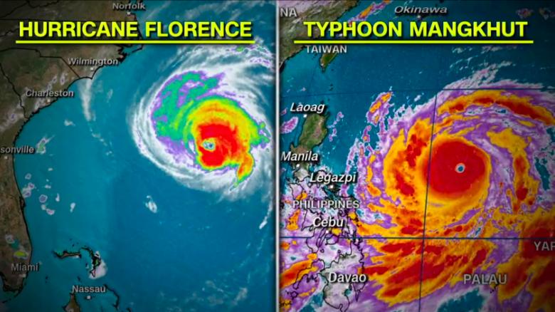
Crazy thing is the one in the south Pacific that is about to slam Philippines is the size of all of EuropeLook at the friggin' size of this thing!
Could be a repeat of the Texas Tower off our coast. Hope he is insured.
Had to look that up.. Texas Tower 4.. sad, avoidable.
No major or even minor changes to the forecast track or intensity with the 11 am NHC advisory. Winds are down to 105 mph, but the storm is definitely better organized than this morning and is expected to strengthen back to at least 110 mph and maybe 115 mph as it goes over the deep, warm Gulf stream in the next 6-12 hours. We'll see. Here's the updated track and intensities; the rainfall and storm surge graphics are about the same.
FORECAST POSITIONS AND MAX WINDS
INIT 13/1500Z 33.4N 75.5W 90 KT 105 MPH
12H 14/0000Z 33.9N 76.6W 95 KT 110 MPH
24H 14/1200Z 34.2N 77.8W 85 KT 100 MPH...NEAR THE COAST
36H 15/0000Z 34.1N 78.7W 65 KT 75 MPH...INLAND
48H 15/1200Z 34.0N 79.6W 45 KT 50 MPH...INLAND
72H 16/1200Z 34.3N 81.8W 25 KT 30 MPH...INLAND
96H 17/1200Z 36.9N 83.0W 25 KT 30 MPH...INLAND
120H 18/1200Z 40.3N 79.2W 20 KT 25 MPH...POST-TROP/EXTRATROP
Again, little change from the NHC on the track and the winds are down to 100 mph. We're now about 12-18 hours from landfall, as the storm has slowed down quite a bit and "landfall" will take hours - or days if the storm stays just along the coast from NC down to SC, as is possible - it's still not a given that Florence slowly goes inland from the Wilmington area.
FORECAST POSITIONS AND MAX WINDS
INIT 13/2100Z 33.7N 76.2W 85 KT 100 MPH
12H 14/0600Z 34.1N 77.2W 85 KT 100 MPH
24H 14/1800Z 34.2N 78.2W 75 KT 85 MPH...INLAND
36H 15/0600Z 33.9N 79.0W 50 KT 60 MPH...INLAND
48H 15/1800Z 33.8N 79.9W 35 KT 40 MPH...INLAND
72H 16/1800Z 34.8N 82.3W 25 KT 30 MPH...INLAND
96H 17/1800Z 37.9N 82.6W 20 KT 25 MPH...POST-TROP/INLAND
120H 18/1800Z 42.7N 76.3W 20 KT 25 MPH...POST-TROP/INLAND

Last edited:
Wouldn’t it be fair to drop the hurricane warning in favor of a tropical storm warning north of Hatteras at this point? Nobody really expects hurricane conditions on Bodie Island, right?

Similar threads
- Replies
- 64
- Views
- 2K
- Replies
- 62
- Views
- 3K
- Replies
- 477
- Views
- 12K
OT: Minor to Moderate (2-4?) Snowfall Likely Sat morning (2/17); will be <32F, so expect slick roads
- Replies
- 213
- Views
- 5K
- Replies
- 122
- Views
- 4K
ADVERTISEMENT
ADVERTISEMENT